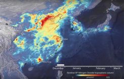
Analysis of satellite imagery shows reduced NO2 in China, Italy
March 23, 2020
Descartes Labs, a geospatial data analytics company, is using satellite imagery analysis to examine how the coronavirus reduced […]
Read More
Descartes Labs, a geospatial data analytics company, is using satellite imagery analysis to examine how the coronavirus reduced […]


Follow Us