
ESA to research monitoring of ground hazards affecting transportation
March 15, 2016
Operators of UK transport networks will be the first to benefit from Live Land, a satellite-based land monitoring system […]
Read More
Operators of UK transport networks will be the first to benefit from Live Land, a satellite-based land monitoring system […]

CoreLogic, a residential property information, analytics and data-enabled services provider, today released an expanded version of its natural […]
Sixty seconds may not sound like much, but if given advance warning of an earthquake, people could take cover, […]
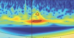
The April 25 magnitude 7.8 earthquake in Nepal created waves of energy that penetrated into Earth’s upper atmosphere […]
Esri has added a pair of new maps to its Nepal Earthquake Maps gallery. Nepal Earthquake Swipe Map […]
Esri has added a pair of new maps to its Nepal Earthquake Maps gallery. Nepal Earthquake Swipe Map […]
Aeryon Labs, GlobalMedic and Monadrone are working together to deploy three unmanned aerial systems (UAS) in Nepal to help locate […]
Following Nepal’s devastating magnitude 7.8 earthquake on Saturday, Airbus Defence and Space has acquired Pléiades satellites imagery to […]


Follow Us