
Google rolls out emergency service
September 17, 2016
With more than 70 percent of calls to emergency services coming from mobile phones, getting necessary help — […]
Read More
With more than 70 percent of calls to emergency services coming from mobile phones, getting necessary help — […]

The FCC ordered that within six years, the elusive z-axis, or altitude, be added to requirements and meet accuracy standards in cases when there is no dispatchable location.
Esri is hosting a free one-hour webinar “Effective Vector-Borne Disease Surveillance and Control” on Thursday, May 26, at 11 […]
From bioterrorism to natural disaster emergency management, predictive analytics used with geospatial tools and Big Data is proving to be a powerful new intelligence tool that may help counter global threats.
When I was the GIS manager of the Atlanta Regional Commission, the most rewarding and important work we […]
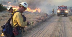
Every year thousands of acres of forests are engulfed in fires. Recognizing the benefits of geospatial technology, the […]

A UAV project, POSEIDRON, took top honors in the 2015 European Satellite Navigation Competition, which recognizes the year’s best innovations […]
STMicroelectronics is bringing next-generation satellite navigation to today’s drivers with the launch of enhanced, always-available, always-accurate 3D […]


Follow Us