Trimble’s GeoExplorer GNSS Data Collection Adds Remote Positioning Capability
November 11, 2013
Trimble has introduced the next generation of its Trimble GeoExplorer data collection solution. The new Geo 7X includes […]
Read More
Trimble has introduced the next generation of its Trimble GeoExplorer data collection solution. The new Geo 7X includes […]
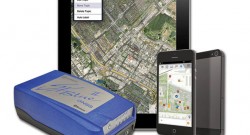
Geneq Inc. announces the iSXBlue II GNSS, a sub-meter GNSS receiver that is Bluetooth-compatible with Apple iPads and […]
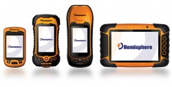
Today, Hemisphere GNSS announced an all-new series of rugged mobile handheld devices with application software options to support […]

F4 Devices has released the Forge Echo for forestry professionals. “Shipping the first product out this week is […]
F4Devices, a subsidiary of F4 Tech and strategic partner with BAP Precisions, Taiwan, has introduced a new generation of high-precision GNSS devices for GIS field applications, the Flint rugged handheld. With the new Flint handheld, field workers requiring a rugged mobile handheld device have a unit that is lightweight, compact, rugged, and cost-effective, the company said. The Flint fits well into GIS field data collection markets such as municipalities, oil and gas and forestry, F4Devices said.
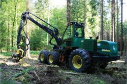
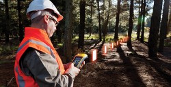
Modern machines such as wood harvesters can automatically cut trees and remove branches, but an expert is still needed to plan a thinning and to mark the trees to be felled. The process can be accelerated if the forest ranger can virtually mark trees to be cut, using geographic coordinates instead of colored crosses sprayed on the stems. This requires the robotic wood harvester to be able to locate itself accurately to enable automatic navigation to the next tree for cutting.
Absorption of the GPS signal in the forest canopy leads to poor results, however, with errors up to 50 meters and more.


Follow Us