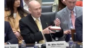
UTTO partners wih GEODNET for utility mapping
October 13, 2025
The partnership enables UTTO to leverage GEODNET’s global RTK correction services across its solutions.
Read More
The partnership enables UTTO to leverage GEODNET’s global RTK correction services across its solutions.
GEODNET, provider of a decentralized real-time kinematic (RTK) network, has launched GEO-MEASURE, a survey-grade GNSS rover that delivers […]
[SPONSORED CONTENT] Mike Horton, project creator of GEODNET, recently testified before the U.S. Congress on behalf of both GEODNET and the broader DePIN (Decentralized Physical Infrastructure Networks) ecosystem.
DroneDeploy has entered a strategic partnership with the GEODNET Foundation to enhance enterprise UAV capabilities.
Bad Elf and GEODNET have introduced a five-year RTK service for Bad Elf GPS receivers, designed to provide high-accuracy GPS positioning.
The GEODNET Foundation has introduced GEO-PULSE, a GPS navigation device to enhance positioning accuracy for everyday drivers.
Propeller, a cloud-based worksite mapping and UAV analytics company, has partnered with GEODNET to upgrade its survey-grade mapping solutions.
Follow Us