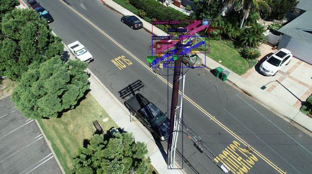
NV5 Geospatial uses remote sensing for utility distribution management
November 28, 2022
Asset and vegetation management applications help utilities minimize risk and improve the reliability of electric distribution networks Geospatial […]
Read More
Asset and vegetation management applications help utilities minimize risk and improve the reliability of electric distribution networks Geospatial […]

The agreement will enable direct access to Xplore’s satellite tasking and archive of high-resolution data Xplore Inc., a […]

Initiative aims to increase the global coverage, quality and accessibility of seabed mapping data through collaboration and the […]

Hexagon AB, a global leader in digital-reality solutions, has announced the following organizational changes to meet the fast-growing […]
Many have debated how the surveying profession has morphed into something less than what our predecessors would have […]
NV5 Geospatial, powered by Quantum Spatial, has launched INSITE, a comprehensive cloud-based platform that enables users to more […]

SimActive Inc., a developer of photogrammetry software, has integrated its Correlator3D product into lidar systems for drones developed […]
SimActive’s Correlator3D software is being used by by Dutch company NEO B.V. to assess solar potential in multiple […]


Follow Us