Google Maps Takes Street View Camera through Amazon Canopy
March 2, 2015
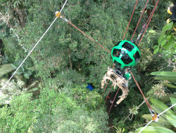
New imagery of the highest canopy in the Amazon rainforest is now available on Google Maps. The Amazon […]
Read More
New imagery of the highest canopy in the Amazon rainforest is now available on Google Maps. The Amazon […]

Hard to believe, we have only now reached the 10th anniversary of Google Maps. As important as digital maps have become, their purpose is much the same as the printed and drawn maps that preceded them. Digital maps emerged in the 1960s with the Census Bureau’s DIME maps. These first digital maps were used for analysis of place-specific data, such as populations within census tracts or cities. Digital maps in turn led to geographic information systems (GIS) for spatial analysis. Though GIS had uses in fields like city planning, the main stimulus for digital maps came in the 1990s with the convergence of the completion of GPS infrastructure, and affordable and portable computers.
Computer security company Absolute Software Corporation is extending its products to use Google Maps to provide improved device geolocation tracking […]
Advanced Search Engine Replaces Google Local Search in 122 Countries deCarta, Inc., an independent LBS platform company, is now […]
Steven Spriggs was pulled over by a motorcycle cop for using his iPhone while driving. He immediately held […]
Google Maps now has Terrain View, which enables users to see terrain maps for an area. Terrain view […]
Ubisense, a location intelligence solutions company, has become an Authorized Partner of solutions based on Google’s Enterprise Maps […]
Ubisense, a location intelligence solutions company, has become an Authorized Partner of solutions based on Google’s Enterprise Maps […]


Follow Us