Drones detect moss beds and changes to Antarctica climate
July 28, 2025
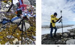
GNSS and unmanned aerial vehicles (UAVs) have revolutionized precise mapping in polar regions. For a team from Queensland […]
Read More
GNSS and unmanned aerial vehicles (UAVs) have revolutionized precise mapping in polar regions. For a team from Queensland […]
Raytheon will build the Geostationary Littoral Imaging and Monitoring Radiometer (GLIMR) sensor under a contract from the University […]
Leica Geosystems, Aibotix and Headwall Photonics are offering an integrated high-performance airborne sensor solution using a hyperspectral imager and […]


Follow Us