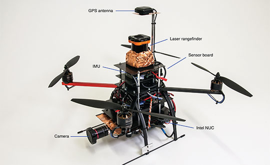
Skip to content

TAG: inertial navigation system

Headshot: Chris Hogstrom

Transportation requires a fusion; now to test it

December 14, 2020

Tree canopy data. (Image: OxTS)

Latest OxTS tool combines inertial and lidar point-cloud data

December 1, 2020

FIGURE 1. Components of the quadrotor helicopter. (Photo: K. Mueller, J. Atman, N. Kronenwett & G.F. Trommer)

Innovation: A multi-sensor navigation system for outdoors and indoors

November 20, 2020

A UAV from SPH Engineering tows a bathymetric sonar just under the surface of a river. (Photo: SPH Engineering)

The shape of water: bathymetry in action

November 10, 2020

Photo: Advanced Navigation

Plug-and-play compass selected for survey package

November 3, 2020

The Ellipse-N INS/GNSS (Photo: SBG Systems)

SBG Systems supports education with inertial navigation technology

October 12, 2020

GAJT-710ML anti-jam antenna. (Photo: Hexagon)

Four decades of leadership

September 30, 2020

The F-22 is one of the lead platforms for EGI-M integration. (Photo: Staff Sgt. Carlin Leslie/U.S. Air Force)

Northrop Grumman’s EGI-M navigation system completes critical design review

September 8, 2020