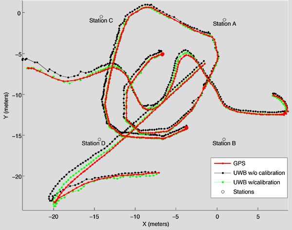
Skip to content

TAG: Innovation

FIGURE 1. Illustration of conventional PPP measurement and error modeling in state-space Hatch filter, resulting in reduced position error in time. FIGURE 2. Conventional geodetic GPS PPP positioning performance characteristics of initial convergence period and steady state for station ALGO, Algonquin Park, Canada, on Jan. 2, 2017. (Image: Sunil Bisnath, John Aggrey, Garrett Seepersad and Maninder Gill)

Innovation: Examining precise point positioning now and in the future

March 19, 2018

1
FIGURE 1. An artist’s view of the QZSS satellites. The upper-most satellite is the geostationary QZS-3 spacecraft with the additional S-band dish antenna whereas the other satellites pictured are the inclined geosynchronous satellites. (Image: Mitsubishi Electric/JAXA)

Innovation: QZS-3 and QZS-4 join the Quasi-Zenith Satellite System

February 9, 2018

2
Courtesy of SPCOMNAV, Universitat Autònoma de Barcelona

Innovation: The continued evolution of the GNSS software-defined radio

January 18, 2018

3
Image: GPS World

Mining the magic “More” menu — again

October 15, 2017

This article is tagged with , , , , and posted in Opinions, Resources
4
FIGURE 1. IMU sensor and setup. (Image: Authors)

Innovation: Checking the accuracy of an inertial-based pedestrian navigation system with a drone

May 24, 2017

5
Photo: GPS World

GPS World editor to moderate innovation panel at Munich Summit

March 6, 2017

This article is tagged with , , , , and posted in Featured Stories, GNSS, Latest News
6
FIGURE 2. SF-PPP solution displayed on a 5-centimeter accurate road infrastructure map, on Dec. 18, 2014.

Innovation: Guidance for road and track

January 14, 2016

This article is tagged with , , , and posted in Innovation, Transportation
7
Figure 1. Overview of a representative eLoran system.

Innovation: Enhanced Loran

November 23, 2015

This article is tagged with , , , , and posted in GNSS, Innovation
8