EOS platform offers worldwide satellite imagery
September 12, 2019
EOS has partnered with four high-resolution imagery providers — Airbus Defense and Space, SI Imaging Services, SpaceWill and […]
Read More
EOS has partnered with four high-resolution imagery providers — Airbus Defense and Space, SI Imaging Services, SpaceWill and […]
A major use of remote sensing data is to compare images of an area taken at different times […]
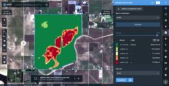
LandViewer, a cloud service developed by EOS Data Analytics, provides access to satellite data and fast-paced analytics. In […]


Follow Us