GIS technology plays crucial role in wildfire management and response
February 7, 2025
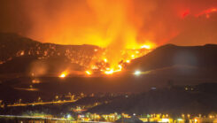
During times of emergency, geographic information systems (GIS) specialists come together to create real-time mapping tools.
Read More
During times of emergency, geographic information systems (GIS) specialists come together to create real-time mapping tools.

The 2025 Los Angeles Geospatial Summit will be held Feb. 28 at the USC Hotel in Los Angeles.

Scientists have discovered new evidence for active volcanism next door to some of the most densely populated areas […]

The Fifth Annual Los Angeles Geospatial Summit will take place at the Japanese American National Museum on Feb. 27, […]
The Fifth Annual Los Angeles Geospatial Summit will take place at the Japanese American National Museum on Feb. 27, […]


Follow Us