Riegl expands airborne and UAV sensor product range
November 7, 2018
Riegl now offers several new sensors and systems for airborne data gathering at various elevations. At Intergeo 2018, […]
Read More

A roundup of recent products in the GNSS and inertial positioning industry from the November 2018 issue of GPS World magazine.

The UAV inspection industry continues to grow, as evidenced by these photos of actual end-user application. Unmanned systems […]

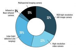
New sensing and software tech spurs growth While UAVs are an exciting new technology for mapping, most respondents […]

Trends, Obstacles and Opportunities Conducted online in July 2018, the GPS World State of the GNSS Industry survey […]

No, this is not a drill or a major motion picture event. During my lifetime, many natural disasters […]
Geospatial companies played a key role in the government’s response to the Kilauea Volcano eruption. The volcano on the Big Island of Hawaii began erupting May 3, and while quiet for more than a week, it could resume erupting at any time.

Using lasers in conjunction with GPS can collect richer data, faster, and streamline survey and mapping projects across […]
Follow Us