Using contact tracing and GPS to fight spread of COVID-19
June 3, 2020
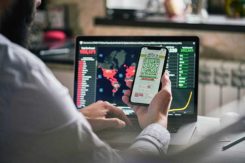
Tracing Location Contact tracing can help stem the spread of the COVID-19 pandemic. It involves tracking the movement […]
Read More
Tracing Location Contact tracing can help stem the spread of the COVID-19 pandemic. It involves tracking the movement […]

Creating detailed street maps and keeping them updated is an expensive and time-consuming task performed mostly by large […]
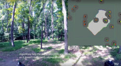
Researchers at the Massachusetts Institute of Technology (MIT) presented a project at the International Symposium on Experimental Robotics […]

A team from Draper and the Massachusetts Institute of Technology (MIT) has developed advanced vision-aided navigation techniques for […]


Follow Us