
Ford Studies Space Robots for Connected Vehicle Communications
September 9, 2013
Ford is studying communications between space robots and Earth to enhance future applications of the connected-car communications protocol. […]
Read More
Ford is studying communications between space robots and Earth to enhance future applications of the connected-car communications protocol. […]
URISA (Urban and Regional Information Systems Association) announced their 2012 GIS Hall of Fame inductees. URISA established the […]
Led by Dr. Attila Komjathy, who received his Ph.D. from the University of New Brunswick in 1997, a team from NASA’s Jet Propulsion Laboratory has demonstrated a technique that has the potential to significantly improve tsunami monitoring and warning. The technique uses data from multiple Global Positioning System receivers on the ground to measure small perturbations in the ionosphere’s electron density caused by a tsunami.
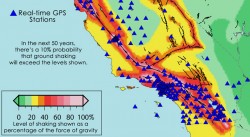
The space-based technology that lets GPS-equipped motorists constantly update their precise location will undergo a major test of its ability to rapidly pinpoint the location and magnitude of strong earthquakes across the western United States. Results from the new Real-time Earthquake Analysis for Disaster (READI) Mitigation Network soon could be used to assist prompt disaster response and more accurate tsunami warnings.
The European Space Agency has issued an intriguing Intended Invitation To Tender, “Weak GNSS Signal Navigation on the Moon.” The study will investigate use of weak-signal GPS/GNSS — and of course ESA is interested primarily in the use of Galileo — for real-time position, navigation and timing information to various future lunar assets such as automated landers, rovers, Earth-Moon transportation vehicle, in-situ navigation, and so on.
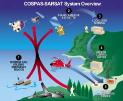
Taking the Search out of Search and RescueIn 1997, a Canadian government study determined that an improved search and rescue system would be one based on medium-Earth orbit satellites, which can provide full global coverage, can determine beacon location, and would need fewer ground stations. This month’s column examines the architecture of the GPS-based Distress Alerting Satellite System and takes a look at early test results.
At this moment, National Aeronautics and Space Administration (NASA) satellites outfitted with advanced sensors are gathering masses of data about phenomena that affect all of us: rainfall patterns, solar irradiation, and tropical deforestation, to name a few


Follow Us