The differences between published Geoid18 and Geoid12B values in Southern Louisiana
April 1, 2020
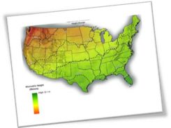
My February 2020 column provided an analysis of the differences between the latest published hybrid Geoid18 values provided […]
Read More
My February 2020 column provided an analysis of the differences between the latest published hybrid Geoid18 values provided […]
My last column, December 2019, highlighted the National Geodetic Survey’s (NGS) new Geoid Monitoring Service (GeMS); and, that […]
![Figure 27: GRACE Trend over CONUS from UTCSR RL06 Model [mm/yr] (Source: Figure 27 from Technical Report NOS NGS 69)](https://stage.gpsworld.com/wp-content/uploads/zilkoski-december-2019-column-image-19-245x187.jpg)
The National Geodetic Survey (NGS) has published a technical report that describes options for how NGS can implement […]
A famous quote applies to almost everything in our lives: “There is nothing permanent except change.” This well-known […]
My last column highlighted the next phase of the National Geodetic Survey’s (NGS) GPS on Bench Marks program; […]
In what seems like just yesterday, GPS World published my article in the May 2017 issue of Survey […]
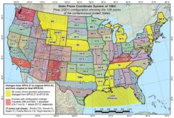
The National Geodetic Survey (NGS) is now developing the 2022 transformation model. Once again, NGS requests the assistance […]
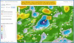
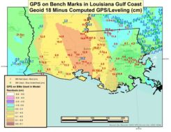
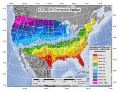
This column discusses the results of the National Geodetic Survey (NGS) beta hybrid Geoid18 model and the differences […]


Follow Us