
Trimble Adds Two Handhelds to GIS Data Collection Portfolio
October 4, 2012
Trimble introduced today the Trimble Geo 5 and Juno 5 handheld GNSS devices, further extending Trimble’s portfolio for […]
Read More
Trimble introduced today the Trimble Geo 5 and Juno 5 handheld GNSS devices, further extending Trimble’s portfolio for […]
Esri, PCI Geomatics, MDA, and RapidEye announced their new Natural Resources Imagery Grant Program. The grant program will provide software, data, and training for detecting and analyzing land-cover change through the combined use of geographic information system (GIS), image processing, and remote-sensing technologies.
A fleet of 100 robots equipped with GPS and sensors were released May 9 into California rivers to measure water flow, salinty levels, and pollution. The Floating Sensor Network is a project by the University of California, Berkeley, to improve the way water quality and flows are monitored. About two-thirds of California’s fresh water is in the Sacramento-San Joaquin river system where the test took place. This water supplies about two-thirds of the state’s population with drinking water and irrigation. The initiative is led by associate professor Alexandre Bayen at the Center for Informatin Technology Research in the Interest of Society (CITRIS).
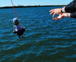
Swarms of robots equipped with GPS and sensors were released May 9 into California rivers to measure water flow, salinty levels, and pollution, reports OurAmazingPlanet.com. The Floating Sensor Network is intended to change the way water quality and flows are monitored in the Sacramento-San Joaquin river system.
F4Devices, a subsidiary of F4 Tech and strategic partner with BAP Precisions, Taiwan, has introduced a new generation of high-precision GNSS devices for GIS field applications, the Flint rugged handheld. With the new Flint handheld, field workers requiring a rugged mobile handheld device have a unit that is lightweight, compact, rugged, and cost-effective, the company said. The Flint fits well into GIS field data collection markets such as municipalities, oil and gas and forestry, F4Devices said.
The Earth’s surface is constantly shifting, being deformed as earthquake faults accumulate strain, and slip or slowly creep over time. Not long ago, scientists relied solely on seismometers to monitor the earth’s movements. Today, GPS has taken prominence as an indispensible tool. PANGA, the monitoring network covering the Pacific Northwest, uses GPS to monitor this movement by measuring the precise position (within 5 millimeters or less) of stations near active faults relative to each other. By determining how the stations have moved, ground deformation can be determined.
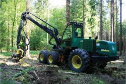
Modern machines such as wood harvesters can automatically cut trees and remove branches, but an expert is still needed to plan a thinning and to mark the trees to be felled. The process can be accelerated if the forest ranger can virtually mark trees to be cut, using geographic coordinates instead of colored crosses sprayed on the stems. This requires the robotic wood harvester to be able to locate itself accurately to enable automatic navigation to the next tree for cutting.
Absorption of the GPS signal in the forest canopy leads to poor results, however, with errors up to 50 meters and more.
At this moment, National Aeronautics and Space Administration (NASA) satellites outfitted with advanced sensors are gathering masses of data about phenomena that affect all of us: rainfall patterns, solar irradiation, and tropical deforestation, to name a few


Follow Us