
Track Hurricane Joaquin with Maps, Social Media
October 1, 2015
Esri is providing a continuously updated hurricane map that shows the projected paths, storm surge, weather warnings and precipitation […]
Read More
Esri is providing a continuously updated hurricane map that shows the projected paths, storm surge, weather warnings and precipitation […]
Esri has published an interactive Wildfire Public Information Map and a 2015 California Wildfire Activity Map. Wildfire Public Information Map […]

A new GPS survey of Mount McKinley, the highest point in North America, will update the commonly accepted […]
Surveyors, prepare to get your feet wet. Global warming is about to hit you in the job list. By 2050, a majority of U.S. coastal areas are likely to be threatened by 30 or more days of flooding each year. This according to a December report in Earth’s Future, a journal of the American Geophysical Union.
Esri’s interactive Severe Weather Public Information Map and U.S. Snowfall Forecast Map enable users to see winter storms, […]
GeoOptics, a satellite-based environmental data services company, in cooperation with Atmospheric and Environmental Research (AER), an environmental research and development company, has announced the initial results of an Observing System Simulation Experiment (OSSE) showing the reliability of radio occultation data in improving predictions of severe weather and flash flood events.
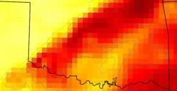
Following the first official day of summer, many areas in the United States are approaching their highest temperatures […]
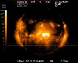
Forecasters at NOAA’s Space Weather Prediction Center said the sun’s coronal mass ejection (CME) that reached Earth on […]


Follow Us