V6 of Virtual Surveyor provides streamlined workflows with drones
July 16, 2018
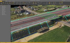
The newly released version 6 of the Virtual Surveyor drone surveying software offers a faster, more efficient workflow and […]
Read More
The newly released version 6 of the Virtual Surveyor drone surveying software offers a faster, more efficient workflow and […]

SimActive Inc., a developer of photogrammetry software, has released Correlator3D version 7.1 with new technology for true orthophotos. Users can […]
Overcoming the challenges of mapping terrain in difficult conditions at altitudes exceeding 14,000 feet using a small unmanned aircraft system (sUAS), Black Swift Technologies demonstrated that a sUAS can successfully be deployed at extreme altitudes.
Avenza Systems Inc., producers of MAPublisher cartographic software for Adobe Illustrator and the PDF Maps mobile app, has […]


Follow Us