Septentrio AsteRx-i provides IMU-enhanced GNSS positioning
April 23, 2018
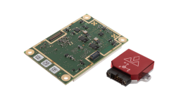
GNSS receiver manufacturer Septentrio has launched the next-generation AsteRx-i at the IEEE/ION Position Location and Navigation Symposium in […]
Read More
GNSS receiver manufacturer Septentrio has launched the next-generation AsteRx-i at the IEEE/ION Position Location and Navigation Symposium in […]

By Simon Batzdorfer, Markus Bobbe, Martin Becker and Ulf Bestmann, Technische Universitaet Braunschweig All images courtesy of the […]

SenseFly is partnering with Trimble to optimize the drone mapping workflow for geospatial professionals. The new integration is designed to […]

Commercial drone-maker Delair has introduced a professional unmanned aerial vehicle (UAV) for survey-grade photogrammetric mapping. The UX11 is a […]

Professional drone company Wingtra is partnering with photogrammetry company Pix4D. Pix4D’s software suite is now available to WingtraOne users, both directly and […]
Hexagon AB showcased its geospatial and construction portfolio at Intergeo 2017 in Berlin, Germany. Hexagon’s sensor portfolio combined […]

It’s almost September. For the GPS World staff, this means scramble time. We have two important industry events […]
We’ve entered a new golden age for photogrammetry, powered by the ease of digitizing images and their ubiquitous […]


Follow Us