
Icaros to Unveil Versatile Nadir/Oblique Aerial Mapping System at InterGeo
October 3, 2014
Icaros, Inc., a provider of aerial remote sensing and 3D visualization solutions, will unveil the IDM 1000 digital […]
Read More
Icaros, Inc., a provider of aerial remote sensing and 3D visualization solutions, will unveil the IDM 1000 digital […]
Icaros Inc., a provider of advanced aerial remote sensing and 3D visualization solutions, will demonstrate the Icaros Measurement […]

Icaros Inc., a provider of advanced aerial remote sensing and 3D visualization solutions, will introduce its Icaros Measurement […]
Leica Geosystems Inc. today announced that Tuck Mapping Solutions Inc. has completed the first integration of a Leica […]
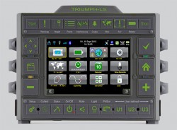
JAVAD GNSS has launched a new version of the TRIUMPH GNSS receiver, which features 864 channels — more […]

Trimble has introduced its next-generation Unmanned Aircraft System (UAS) — the Trimble UX5 aerial imaging rover with the […]
Trimble has introduced a new version of its office surveying software — Trimble Business Center Software version 3.00. […]


Follow Us