New Soar platform gives public real-time views of world events
October 25, 2019
Satellite imagery company Soar is now allowing public access to its satellites that provide near-real time imagery all across […]
Read More
Satellite imagery company Soar is now allowing public access to its satellites that provide near-real time imagery all across […]
EOS has partnered with four high-resolution imagery providers — Airbus Defense and Space, SI Imaging Services, SpaceWill and […]
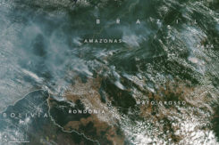
Wildfires in the Amazon rainforest in Brazil have hit record numbers, and satellites have been able to capture […]

Airbus has enlarged its high-resolution imagery portfolio following an agreement to leverage capacity from the S1-4 satellite built […]
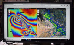
Esri’s Jesse Smith discusses how the U.S. Coast Guard’s International Ice Patrol is using Esri’s ArcGIS Enterprise platform […]

I was inspired by the 50th anniversary of the Moon landing on July 16 and our focus on […]
The new Earth Monitor tool draws from the Airbus imagery archive and satellite tasking capabilities to provide advanced […]
Satellite imagery and mapping have proven to be critical technologies when it comes to disaster relief efforts. The […]


Follow Us