
NASA Disasters Program offers satellite imagery, maps for disaster response
July 21, 2019
Jeremy Kirkendall, senior GIS administrator for the NASA Disasters Program, gives GPS World an overview of the program […]
Read More
Jeremy Kirkendall, senior GIS administrator for the NASA Disasters Program, gives GPS World an overview of the program […]
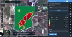
A major use of remote sensing data is to compare images of an area taken at different times […]
A major use of remote sensing data is to compare images of an area taken at different times […]
Airbus Defence and Space and The Climate Corporation, a subsidiary of Bayer, have announced a global agreement to […]
Swedish Space Corporation (SSC) and Airbus have signed a contract for SSC ground segment support services to the […]
TCarta Marine, a global provider of geospatial products and services, has been contracted by the United Kingdom Hydrographic […]
LandViewer, a cloud service developed by EOS Data Analytics, provides access to satellite data and fast-paced analytics. In […]
Planet (formerly Planet Labs) has put about 300 satellites into space, in charge of photographing the entire land […]


Follow Us