NASA releases satellite damage map of Camp Fire
November 26, 2018
The Advanced Rapid Imaging and Analysis (ARIA) team at NASA’s Jet Propulsion Laboratory in Pasadena has produced a […]
Read More
The Advanced Rapid Imaging and Analysis (ARIA) team at NASA’s Jet Propulsion Laboratory in Pasadena has produced a […]

TCarta, a global provider of geospatial products and services, was commissioned by the Environment Agency — Abu Dhabi […]
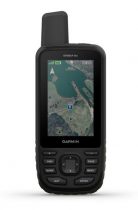
Garmin International is offering a new outdoor GPS handheld that can log raw measurements in RINEX form, the GPSMAP […]
Synthetic aperture radar (SAR) imagery from Maxar’s MDA RADARSAT-2 satellite will become available to SecureWatch subscribers on Oct. […]
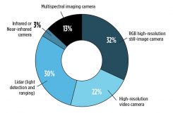
New sensing and software tech spurs growth While UAVs are an exciting new technology for mapping, most respondents […]
DigitalGlobe has released pre- and post-event satellite imagery of the areas in India affected by heavy flooding. According […]
Airbus and Planet have entered into a partnership to facilitate access to each other’s data and the co-development […]
Airbus Defence and Space is celebrating the 25th anniversary of Eagle Vision, its lightweight deployable imagery downlink ground […]


Follow Us