
SuperGeo Technologies Introduces SuperPad 3.1
May 16, 2012
SuperGeo Technologies introduces SuperPad 3.1, which mainly enhances the user interface, adjusts toolbar icons, adds SBAS extension, and improves the display of GPS status.
Read More
SuperGeo Technologies introduces SuperPad 3.1, which mainly enhances the user interface, adjusts toolbar icons, adds SBAS extension, and improves the display of GPS status.
According to a spokesperson from the Space and Missile Systems Center, GPS Directorate, the Russian Space Agency (RSA) has been assigned L1 pseudorandom noise (PRN) C/A codes for its System of Differential Correction and Monitoring (SDCM) transponders on the Luch series of geostationary relay satellites.
Proposals made at a December 27 Moscow meeting on the status and future of the satellite constellation included one to expand the GLONASS constellation to 30 satellites using six orbital planes. Five other options for upgrading the constellation were also aired.
Precise positioning of many different kinds of vessels and other equipment depend upon satellite-based augmentation systems (SBAS) of GNSS, principally GPS and GLONASS at this time. The applications range from exploration to production and delivery of hydrocarbons to shore-based installations and navigation of very large crude carriers, or oil tankers. Decisions and recommendations are strongly needed to keep these services free from interference.
First Overload Interference/Desensitization to GPS Receivers, Systems, and Networks Report to FCC; Plus Save Our GPS Coalition Forms; WAAS Official Again; EGNOS SOL Operational; Russian SBAS Satellite Passes Transponder Tests
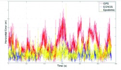
GPS corrections from the European Geostationary Navigation Overlay Service can improve the positioning accuracy and user experience of GPS-enabled mobile phones, even if EGNOS satellites are not visible and even when the GNSS chipset in the phone does not support satellite-based augmentation systems.
Last week, I conducted a webinar along with Dr. Michael Whitehead titled “SBAS, DGPS or Post-processing? Which Should You Use?” It was one of the best webinars I’ve conducted to date. We barely squeezed it into 65 minutes and could have kept going for the better part of two hours, given the subject matter to cover and the number of questions we received before and during the webinar.
Look back with me at the five 2010 GNSS events that most affected surveying, mapping, engineering, construction, and natural resource users. Each one had, or could have had, a significant effect on you and your work.


Follow Us