
Advanced Navigation, KVH Release Spatial FOG GNSS/INS
January 8, 2013
Advanced Navigation, in collaboration with KVH Industries, has announced its new Spatial FOG GNSS/INS. Spatial FOG is a […]
Read More
Advanced Navigation, in collaboration with KVH Industries, has announced its new Spatial FOG GNSS/INS. Spatial FOG is a […]
Trimble has introduced the AP20-C, the latest addition to its AP Series of embedded GNSS-Inertial OEM boards plus Inertial Measurement Unit (IMU). Using a compact, custom-built IMU based on commercial Micro Electromechanical Machined (MEMS) inertial sensors, the AP20-C enables system integrators to achieve high-rate position and orientation measurements with exceptional accuracy, Trimble said.
Spirent Communications has launched its SimSENSOR MEMS (Micro-Electro-Mechanical Systems) sensor simulation software. SimSENSOR is targeted at the R&D environment and enables performance testing of sensor fusion algorithms in navigation systems that include MEMS inertial sensors and multi-GNSS.
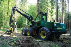
Modern machines such as wood harvesters can automatically cut trees and remove branches, but an expert is still needed to plan a thinning and to mark the trees to be felled. The process can be accelerated if the forest ranger can virtually mark trees to be cut, using geographic coordinates instead of colored crosses sprayed on the stems. This requires the robotic wood harvester to be able to locate itself accurately to enable automatic navigation to the next tree for cutting.
Absorption of the GPS signal in the forest canopy leads to poor results, however, with errors up to 50 meters and more.
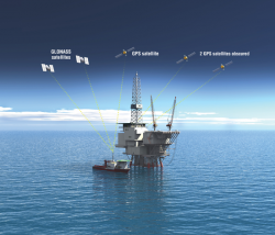
Adding GLONASS to GPS gives a total of about 50 satellites, for a significant improvement in navigation availability, reliability, robustness, and convergence time through a new multi-GNSS precise point positioning (PPP) service. System performance and field results demonstrate that there is no need to await future constellations — better performance is available now.


Follow Us