LabSat’s SatGen v3 Adds BeiDou to Simulator Scenarios
June 22, 2015
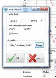
SatGen v3 software is now available for the LabSat GNSS simulator by Racelogic. Version 3 includes BeiDou (BDS) […]
Read More
SatGen v3 software is now available for the LabSat GNSS simulator by Racelogic. Version 3 includes BeiDou (BDS) […]

Data Mapper, an enterprise aerial data software by PrecisionHawk, will expand its cloud-based platform to process data collected by […]

Topcon Positioning Group announces new reference station network software — TopNET+ v10 — bringing new features and functionality […]
RTKLIB, a developer of open source software for standard and precise GNSS positioning, has released its latest RTKLIB […]
A sold-out crowd of more than 650 people filled the Kossiakoff Conference Center at the Johns Hopkins Applied Physics Laboratory on Wednesday, 30 May 2012 to participate in the Open Source Industry Day co-hosted by the National Security Agency and the Open Source Software Institute.
Trimble introduced new versions of its office and field surveying software—Trimble Business Center Software version 2.70 and Trimble Access software version 2012.10. The software is part of Trimble’s portfolio of Connected Site survey solutions.
Leica Geosystems Geospatial Solutions Division is pleased to announce the release of its new mission planning software, Leica MissionPro. The software provides mission planning capability for all airborne sensors including LiDAR, line and frame sensors and is fully integrated into existing Z/I Imaging and Leica Geosystems workflows.


Follow Us