Machine learning boosts GPS precision: New method enhances ambiguity resolution
June 24, 2025
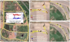
High-precision GNSS applications, such as real-time displacement monitoring and vehicle navigation, rely heavily on resolving carrier-phase ambiguities.
Read More


Follow Us