Android, lidar experts to deliver addresses at ION GNSS+
September 20, 2018
Steve Malkos of Google, and a GPS World contributor, will address the ION GNSS+ plenary session at the […]
Read More

Steve Malkos of Google, and a GPS World contributor, will address the ION GNSS+ plenary session at the […]

Teledyne Optech will exhibit at the United States Geospatial Intelligence Foundation’s GEOINT Symposium April 23-25 in Tampa, Florida. Technology […]

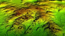
Lidar and UAV technology has revealed hundreds of previously unknown Mayan ruins in the Guatemalan rainforest. In what is […]

Lidar and UAV technology has revealed hundreds of previously unknown Mayan ruins in the Guatemalan rainforest. In what is […]

Coastal Zone Mapping and Imaging Lidar System (CZMIL) to be shared at conferences as a critical rapid environmental assessment […]

A number of geospatial intelligence companies are exhibiting at the GEOINT 2017 Symposium, which is taking place June […]

Teledyne Optech has released its Polaris terrestrial laser scanner, which automatically detects its location with a built-in GNSS […]

Teledyne Optech has added to its line of airborne laser terrain mappers with the ALTM Galaxy T1000. The new system combines […]
Follow Us