Advancing earthquake prediction with a UAV
July 24, 2025
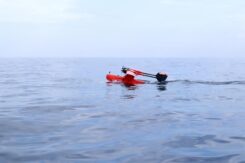
Researchers demonstrate a seaplane-type UAV using GNSS-A can precisely measure seafloor deformation Megathrust earthquakes are large earthquakes that […]
Read More
Researchers demonstrate a seaplane-type UAV using GNSS-A can precisely measure seafloor deformation Megathrust earthquakes are large earthquakes that […]
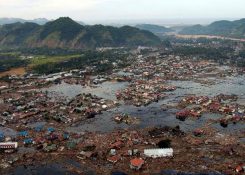
Using data from GPS receivers and seismographs, three seismologists may have found a way to identify tsunami earthquakes […]
No, this is not a drill or a major motion picture event. During my lifetime, many natural disasters […]

Researchers testing a satellite-based earthquake early warning system developed for the U.S. West Coast found that the system […]
Surveyors, prepare to get your feet wet. Global warming is about to hit you in the job list. By 2050, a majority of U.S. coastal areas are likely to be threatened by 30 or more days of flooding each year. This according to a December report in Earth’s Future, a journal of the American Geophysical Union.

CBC News interviewed GPS World Innovation Editor Richard Langley about his ionosphere interference research project with NASA, reported on earlier […]
Abstract submissions are now being accepted for The Institute of Navigation’s (ION) Pacific PNT Conference, to be held April […]
CoreLogic, a global property information, analytics and data-enabled services provider, has released a new version of its EQECAT […]


Follow Us