
Unmanned Systems Show Highlights UAV and UAS Opportunities
May 21, 2014
Just before the start of the huge AUVSI show, the FAA once again cautioned Unmanned Aerial Systems proponents that still more care is needed with UAS airspace access.
Read More
Just before the start of the huge AUVSI show, the FAA once again cautioned Unmanned Aerial Systems proponents that still more care is needed with UAS airspace access.
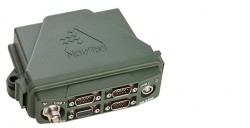
NovAtel has launched the FlexPak-S GNSS SAASM enclosure. The FlexPak-S contains a NovAtel dual-frequency OEM625S receiver card integrated […]

Applanix Corp. and American Aerospace Advisors, Inc. (AAAI), have agreed on an OEM supply agreement that will incorporate […]

Visual Intelligence has announced that its iOne Software Sensor Tool Kit Architecture (iOne STKA) is available for purchase […]
Limited landing area as well as interference due to wind disturbance and wave motion make shipboard landings of unmanned aerial vehicles (UAVs) extremely difficult. Use of UAVs at sea can enhance the efficiency of intelligence gathering and surveillance, and could also increase long-range air-strike capability.

Surveying an open-pit mine can be a hazardous undertaking. To obtain accurate volume measurements, it is necessary to […]
Unmanned aerial vehicles (UAVs), or as most civil aviation authorities now call them, unmanned aircraft systems (UASs), are attracting a lot of attention lately from geospatial professionals. Common questions in their minds are: What applications can I use it in? What benefits can it provide to my organization or my clients (or data users)? How do I implement such a system in my organization? This article will cover the first two questions, while addressing some of the third as well.

Interview with Graham Purves, Executive Vice President, NovAtel GPS World (GPSW): In the regulatory picture for unmanned […]


Follow Us