
New GNSS weather datasets available from TechDemoSat-1
November 29, 2016
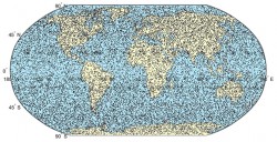
New weather datasets, which could prove highly valuable for weather forecasting and for longer term climate monitoring, have […]
Read More
New weather datasets, which could prove highly valuable for weather forecasting and for longer term climate monitoring, have […]

The membership of the Open Geospatial Consortium (OGC) has approved the OGC CF-netCDF 3.0 encoding using GML Coverage […]
PlanetiQ has signed a contract with Antrix Corporation Limited, the commercial arm of the Indian Space Research Organization […]
The Federal Aviation Administration (FAA) has selected Harris Corporation for an eight-year, single-award indefinite delivery/indefinite quantity (IDIQ) contract with a potential […]
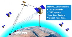
The company PlanetiQ plans to use GNSS to make real-time weather forecasts. PlanetiQ plans to launch a commercial weather satellite […]
Esri’s interactive Severe Weather Public Information Map and U.S. Snowfall Forecast Map enable users to see winter storms, […]
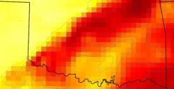
GeoOptics, a satellite-based environmental data services company, in cooperation with Atmospheric and Environmental Research (AER), an environmental research and development company, has announced the initial results of an Observing System Simulation Experiment (OSSE) showing the reliability of radio occultation data in improving predictions of severe weather and flash flood events.
Esri is offering a Severe Weather Public Information Map that charts instances of severe weather throughout the United […]


Follow Us