Listen to this content
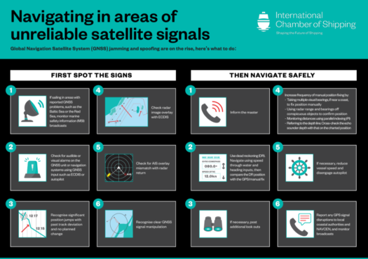
The International Chamber of Shipping (ICS) and its members have produced an informational poster for ship crews that highlights strategies when GNSS signals are jammed or denied.
The Navigating in Areas of Unreliable Satellite Signals poster is available for free on the ICS website. Crews are welcome to download and print it for display near the conning position on board navigation bridges.
Modern maritime operations depend heavily on GNSS. From open-ocean routing to precise harbour maneuvers, satellite-based positioning data is deeply embedded in ship systems, port logistics, traffic monitoring and safety infrastructure.
This reliance, however, has created a growing vulnerability. Incidents of GPS jamming and spoofing, once a military concern, now increasingly affect merchant ships at sea and near ports. Without proactive preparation and mitigation, interference with satellite navigation threatens vessel safety, global trade efficiency, port operations and maritime security.
To support crews facing these incidents, the poster helps bridge officers identify the signs of compromised satellite signals and recommends best practices to maintain safe navigation.
“The safety of our seafarers, ships, and the environment is critical,” said Gregor Stevens, ICS Nautical Director. “With ever-increasing frequency of jamming and spoofing of GPS, this new free resource helps seafarers recognize the warning signs and provides guidance on navigating these waters safely.”