Where Are We Going? Published November 4, 2009 By Eric Gakstatter Join the Discussion It occurred to me that I haven’t discussed my plans for GeoSpatial Solutions (GSS) since I assumed the editorship of GSS a couple of months ago. Some of you have told me that you thought GSS had “gone away.” True, it was somewhat dormant for awhile, but we’ve got some fantastic initiatives underway for 2010 […] Read more » GSS GSS Monthly
Survey ABB Selects Intergraph for North African Gas Pipeline Project Published November 4, 2009 By GPS World Staff Join the Discussion ABB has selected Intergraph for the development of an oil and gas pipeline network and relevant facilities in North Africa. The pipeline network will be built in the El Merk field, a remote, harsh desert location in Algeria. Read more » construction GIS maps oil and gas pipeline surveying
Opinions Survey What’s the Difference between a Used Car Salesman and a GPS Salesman? Published November 3, 2009 By Eric Gakstatter Join the Discussion I didn’t attend the Minnesota GIS/LIS Annual Conference last week, but I received a report from someone who attended a session in which the presenter seemed to fit the maxim quite well. One of the presenter’s messages was that people should stop using WAAS immediately as a GPS correction source due to the inability of data collection software to handle the ITRF00 > NAD83/CORS96 datum shift. Following is a statement from one of his slides… Read more » Survey Scene
Lidar 3D Geospatial Data Published November 1, 2009 By Eric Gakstatter Join the Discussion The usage of three dimensional data in the geospatial industry is in its infancy. It makes sense to me. Sometimes, it’s hard enough for folks to obtain and maintain accurate two dimensional data, not to mention elevation! However, as geospatial technology continues to evolve, the availability of 3D geospatial data will evolve. I’m pretty sure […] Read more » GSS GSS Monthly
Galileo GLONASS GNSS The System: Galileo Slips, EGNOS Operates Published November 1, 2009 By Alan Cameron Four Galileo in-orbit validation (IOV) satellites scheduled to launch next year have already missed their first pad date.The European version of Russia’s Soyuz rocket is now scheduled to carry the four IOV satellites into orbit in two launches in November 2010 and early 2011, as announced by European Space Agency (ESA) Director-General Jean-Jacques Dordain on […] Read more » EGNOS GPS constellation GPS modernization Penny Axelrad The System
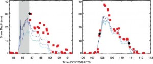
On the Edge: Multipath Measures Snow Depth Published November 1, 2009 By Alan Cameron Join the Discussion The September “Innovation” column in this magazine, “It’s Not All Bad: Understanding and Using GNSS Multipath,” by Andria Bilich and Kristine Larson (see env-gpsworld-integration.kinsta.cloud/multipath), mentions the use of multipath in studying soil moisture, ocean altimetry and winds, and snow sensing. An experiment the authors conducted, designed to study soil moisture, yielded a surprise bonus: a new methodology for measuring snow depth via GPS multipath. It has important implications for weather and flood forecasting, and could also bring new insight to bear on GPS antenna design. Read more » antenna technology multipath OEM signal processing snow depth snowstorm weather forecasting
Uncategorized The True Story of the Origins of GPS Published November 1, 2009 By GPS World Staff Join the Discussion Photos from the GPS World Leadership Dinner 2009, September 24 ION GNSS 2009 Conference, Savannah, Georgia Read more » GPS history GPS World Leadership Dinner GPS World magazine leadership dinner
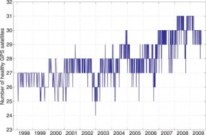
Opinions Expert Advice: GPS Constellation Maxed Out at 30 Published November 1, 2009 By Richard B. Langley Join the Discussion It appears that the GPS satellite constellation has a glass ceiling, so to speak. GPS was designed as a 24-satellite constellation, with four satellites in six orbital planes arranged to provide maximum observability around the globe. According to the government’s Space-Based Positioning, Navigation, and Timing website, “The U.S. government is committed to provide a minimum of 24 operational GPS satellites on orbit, 95 percent of the time. The U.S. Air Force launches additional satellites that function as active spares to accommodate periodic satellite maintenance downtime and assure the availability of at least 24 operating satellites. As of August 28, 2009, there were 35 satellites in the GPS constellation, with 30 set ‘healthy’ to users.” Read more » Expert Advice GPS constellation
Opinions Out in Front: An SVN up for Grabs Published November 1, 2009 By GPS World Staff Join the Discussion Wednesday evening, September 23, Savannah, Georgia, 5:30 to 7:00 p.m., Session P2b — a date that will live in GPS history. The 400 to 600 of us who were there to witness it will never forget it. The SVN49 Review Panel. Unprecedented puts it mildly. Read more » editorial From the Editor SVN-49
Higher Timing Accuracy, Lower Cost Published November 1, 2009 By GPS World Staff Join the Discussion Inside a typical GNSS receiver, the estimate of the error in the local oscillator is formed as a component of the navigation solution, which is in turn based on the output of each satellite-tracking channel propagating its estimate of carrier and code measurements to a common future point. But this method limits the resolution with which the noise of the local oscillator can be quantified. To bypass this shortcoming requires a method of coherently gathering information about the phase change in the local oscillator across all available satellite signals: to use the same samples simultaneously for all satellites in view to estimate the center-point phase error common across the visible constellation. We explore how. Read more » GNSS simulators OEM receiver design simulators timing