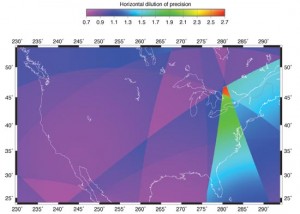
Research & Development Innovation: Improving Dilution of Precision Published November 1, 2009 By Richard B. Langley Join the Discussion A Companion Measure of Systematic EffectsGPS receivers must deal with measurements and models that have some degree of error, which gets propagated into the position solution. If the errors are systematically different for the different simultaneous pseudoranges, as is typically the case when trying to correct for ionospheric and tropospheric effects, these errors propagate into the receiver solution in a way that is fundamentally different from the way that random errors propagate. So in addition to dilution of precision, we need a companion measure of systematic effects. In this month’s column, we introduce just such a measure. Read more » algorithms and methods OEM
TIGER Database Historical Perspective Published October 27, 2009 By Eric Gakstatter Join the Discussion In my last two columns, I’ve made several references to geospatial data. Jon Sperling, Ph.D. GISP, wrote in and commented on the omission of the importance of TIGER data in the history of geospatial data development and commercialization. He made reference to a document he wrote that was published in 1995 regarding the development and […] Read more » GSS Monthly
TIGER Database Historical Perspective Published October 27, 2009 By Eric Gakstatter Join the Discussion In my last two columns, I’ve made several references to geospatial data. Jon Sperling, Ph.D. GISP, wrote in and commented on the omission of the importance of TIGER data in the history of geospatial data development and commercialization. He made reference to a document he wrote that was published in 1995 regarding the development and […] Read more » GSS GSS Monthly
3D Visualization Software and…Introducing a New Contributing Author Published October 24, 2009 By Eric Gakstatter Join the Discussion A couple of weeks ago, I dedicated a column to discussing the emergence of 3D geospatial data. This week, I was navigating around the U.S. Army Geospatial Center’s (AGC) website, which was formerly known as the Engineer Research and Development Center’s Topographic Engineering Center (TEC). As of October 1, 2009, AGC is operating as a Major […] Read more » GSS GSS Monthly
Opinions Survey GPS Constellation Management: Playing Not to Lose Published October 22, 2009 By Eric Gakstatter Join the Discussion In sports, there is a phenomenon that sometimes occurs when a team is leading towards the end of a game. It’s called “playing not to lose.” The reason you are seeing high HDOP warnings from the NAVCEN and GPS “brownouts” during the day when RTK (GPS-only) isn’t working is because the GPS satellite constellation is sub-optimal. The current design of the GPS constellation is not focused on “playing to win”, but rather “playing not to lose.” Read more » GPS constellation Survey Scene
Mapping Geospatial Data Accuracy – Better and Better Published October 20, 2009 By Eric Gakstatter Join the Discussion Circa. 1995. I walked into the GIS office of a major forest products company in northern Arkansas (or was it northern Louisiana…not sure). At the time, I was a product manager for a GPS company and field testing one of our newer GPS mapping hand-held products. We decided to go out and map the perimeter […] Read more » GSS GSS Monthly
Opinions Intelligence on Demand (IOD) Published October 13, 2009 By Art Kalinski Join the Discussion Oblique Imagery Online a Significant Game Changer for Federal Agencies By Art Kalinski, GISP A new technology service has just been initiated that may affect almost every federal employee who needs to view high resolution oblique imagery in the United States and key locations around the world. This service is a joint effort between Pictometry […] Read more » GeoIntelligence Insider GSS
GLONASS GPS Opinions Survey “What Can GLONASS, GPS L2C, and GPS L5 Do for You?” Webinar Q&A Follow-up Published October 6, 2009 By Eric Gakstatter Join the Discussion As I’ve been accustomed to doing, this newsletter addresses the questions you submitted during the Sept. 15 webinar entitled “What Can GLONASS, GPS L2C, and GPS L5 Do for You?”. There were some great questions during the webinar, and a lot of them. There were so many, in fact, that I’m going to break them up into a couple of different newsletter issues. Also, I need to update you on my trip to ION GNSS a couple of weeks ago. I might mix up the next newsletter with more Q&A as well as the ION GNSS update. Read more » L2C L5 Survey Scene
Research & Development Innovation: It’s Not All Bad Published October 1, 2009 By Richard B. Langley Join the Discussion Understanding and Using GNSS MultipathTelltale signs of multipath are the fluctuations in the signal-to-noise ratios (SNRs) reported by some GNSS receivers. In this month’s column, the authors look at how an analysis of SNR values can be used to map the multipath environment surrounding an antenna so that models of multipath can be constructed to further minimize its effect. Also, although an annoyance for most GNSS users, it turns out that multipath has its positive points. Read more » algorithms and methods GNSS receivers multipath multipath mitigation OEM
Lidar Mapping The Struggles of a City GIS Manager Published October 1, 2009 By Eric Gakstatter Join the Discussion This is real. The names have been omitted, but this is happening as I write at one city and I’m willing to bet many, many more cities around the world. The city is typical in the US. Its population is ~23,000. Geographic area is ~8 square miles. There are 430 acres of parkland, over 150 […] Read more » GSS GSS Monthly