Mobile CSR and SiRF Complete Merger Published July 20, 2009 By GPS World Staff Join the Discussion CSR plc of Cambridge, UK, and SiRF Technology Holdings Inc., of San Jose, Califonia, on June 26 completed the merger between SiRF and a wholly owned subsidiary of CSR. The merger resulted in "creating a provider of connectivity and location platforms and a company with the scale, technology, and strategy to enable its customers to address the exciting and emerging opportunities in mobile markets," according to a company statement. Read more » auto navigation CSR in-vehicle services merger mergers and acquisitions mobile device personal navigation SiRF tracking
GNSS Opinions Expert Advice: Cause Identified for Pseudorange Error from New GPS Satellite SVN-49 Published July 15, 2009 By GPS World Staff and Richard B. Langley Join the Discussion The GPS Wing and its contractors have traced the cause of pseudorange errors on L1 and L2 broadcast by the newest GPS satellite, SVN-49, to the manner in which the L5 signal demonstration payload was added to the satellite. Signal leakage between the two input ports of the antenna coupler network for the satellite's array of 12 helical antenna elements, reflected from the L5 filter and then transmitted, creates a second signal with a delay of approximately 30 nanoseconds, and the appearance of a multipath component. While testing an adjustment to the signal-in-space to minimize the effect of the problem on receiver navigation solutions on Earth, the GPS Wing is interested in hearing from manufacturers and the user community concerning the different impacts of SVN-49 signals on the wide range products and applications in operation, before reaching a final decision on what to do with the satellite prior to setting it healthy. Read more » GPS constellation GPS satellite Oliver Montenbruck pseudorange measurements SVN-49
Opinions Letters to the Editor Published July 1, 2009 By GPS World Staff Join the Discussion DAGR and GAO Furors Read more » letters
Opinions Expert Advice: All Rise, GPS Entering the Court Published July 1, 2009 By GPS World Staff Join the Discussion In the litigious society that we have become, it is not surprising to see GPS as a regular fixture in many civil and criminal proceedings in our nation?s courts. A new and growing outlet for the legal profession, it has also engaged many of the older GPS pioneers who, instead of just retiring, have found a relatively lucrative way to spend their free time. They now form the cadre of GPS expert witnesses, without whom many of the cases involving positioning could not be settled equitably. Read more » Expert Advice
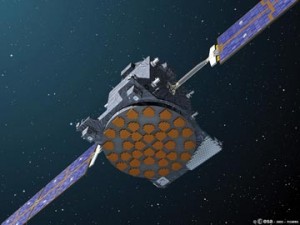
Galileo GNSS Research & Development Innovation: Where Is GIOVE-A Exactly? Published July 1, 2009 By Richard B. Langley Join the Discussion Using Microwaves and Laser Ranging for Precise Orbit DeterminationThough Galileo’s GIOVE-A is a test satellite not necessarily ready for scientific use, orbit analyses with a reduced accuracy can help to identify weaknesses and suggest improvements. This month, the authors share work being carried out to precisely determine the orbit of GIOVE-A using SLR and microwave observations. This preliminary investigation will benefit the procedures to be implemented for the future Galileo constellation. Read more » GIOVE-A laser ranging OEM SLR measurement SLR technique
Lidar ESRI Con: LizardTech Unveils MrSID Compression for Raw LiDAR Data Published June 25, 2009 By Tracy Cozzens Join the Discussion LizardTech’s LiDAR Compressor can convert cloud data into MrSID files that retain 100 percent of the original raw data at just 25 percent of the file size, according to the company. Derivatives can be extracted repeatedly from LiDAR files compressed to MrSID, LizardTech said. It can also reportedly reduce LiDAR file sizes by up 90 […] Read more » GIS GSS lidar LizardTech
Opinions Survey GPS Receivers for GIS Data Collection Published June 22, 2009 By Eric Gakstatter Join the Discussion In my column earlier this month, I discussed the use of consumer GPS receivers for GIS data collection. Remember the analogy I used?a Volkswagen Beetle wasn?t designed to run in a Formula One race? This column is going to focus on the Formula One cars, not the Volkswagen Beetles. In other words, it will focus on the GPS receivers on the market that are designed for GIS data collection. I will refer to them as GPS/GIS receivers. Read more » data collection GIS GPS receiver Survey Scene
Opinions Survey Consumer-Grade GPS Receivers for GIS Data Collection Published June 3, 2009 By Eric Gakstatter Join the Discussion Three categories of GPS are used to populate GIS databases: consumer-grade receivers, GPS receivers designed specifically for GIS data collection, and survey receivers. This month, I discuss consumer-grade receivers. In a new issue in two weeks' time, I?ll cover the class of GPS receivers designed specifically for GIS data collection. Read more » data collection GIS GPS receiver Survey Scene
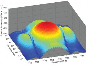
GNSS Research & Development Innovation: GPS L5 First Light Published June 1, 2009 By Richard B. Langley Join the Discussion A Preliminary Analysis of SVN49’s Demonstration SignalGreat excitement surrounds the activation of a new transmitter from a satellite — an occasion dubbed first light. Research groups around the globe joined the GPS Wing in monitoring and analyzing the first L5 signals from space. We describe the equipment and procedures used to capture and analyze SVN49's signals and give an assessment of their characteristics. Read more » GPS constellation GPS L5 GPS modernization GPS satellite L5
Opinions The Mortgage Crisis and GIS Published May 28, 2009 By Art Kalinski Join the Discussion Was the FGDC Mortgage Crisis Meeting a Silver Lining on a Huge Cloud? By Art Kalinski, GISP On May 7, I attended a special meeting addressing the mortgage crisis hosted by the Federal Geographic Data Committee (FGDC) and the International Association of Assessing Officers (IAAO). The purpose of the day long meeting was to discuss […] Read more » GeoIntelligence Insider GSS