Space & Earth ESA’s HydroGNSS satellites launched to scout for water Published December 2, 2025 By Tracy Cozzens The European Space Agency’s first Scout mission, HydroGNSS, was launched Nov. 28, marking a significant step in advancing global understanding of water availability and the effects of climate change on Earth’s water cycle. The two twin HydroGNSS satellites were carried into orbit at 19:44 CET aboard a SpaceX Falcon 9 rocket, as part of the […] Read more » climate change ESA GNSS reflectometry HydroGNSS satellite launch
Survey VBOX Automotive launches NTRIP base station Published December 2, 2025 By Tracy Cozzens Join the Discussion VBOX Automotive has launched the NTRIP Base Station, expanding its GNSS test equipment range. The system combines a multi-constellation, multi-frequency GNSS engine with a built-in networked transport of RTCM via internet protocol (NTRIP) server. The equipment transmits real-time kinematic corrections over radio and cellular or Wi-Fi networks, supporting accurate real-time positioning across wider areas in […] Read more » GNSS base station multi-constellation GNSS NTRIP OEM VBOX Automotive
Survey Mapping Opinions AAGS YouTube seminars on geodetic topics in support of a certificate in geodetic surveying Published December 2, 2025 By David B. Zilkoski Dave Zilkoski shares updates on the American Association for Geodetic Surveying (AAGS) Certificate for Geodetic Surveying Program. Read more » geodesy
Autonomous New mini UAV designed for border patrol Published November 27, 2025 By Tracy Cozzens CopterPIX, an Israeli developer and manufacturer of autonomous multi-rotor UAV solutions, has unveiled its newest platform: the ERE95 Mini. CopterPIX made the announement at UVID Dronetech 2025, which took place Nov. 26 at Expo Tel Aviv. The ERE95 Mini is designed as an operational platform for border protection, long-range surveillance, and ISR missions. It is […] Read more » anti-jamming autonomous vehicles border patrol CopterPix ISR Israel surveillance UAV
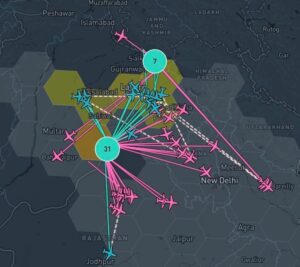
Transportation India’s DGCA clarifies 10-minute GNSS interference reporting requirement Published November 26, 2025 By Tracy Cozzens India’s Directorate General of Civil Aviation (DGCA) has issued an adendum on reporting procedures for suspected GNSS spoofing, reports news service AIN. On Nov. 10, the DGCA began requiring that all spoofing and jamming incidents be reported within 10 minutes, following an intense period of disruptions around Indira Gandhi International Airport in Delhi. The addendum is […] Read more » civil aviation DGCA GNSS interference India Indian government jamming New Delhi spoofing
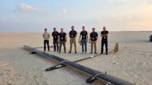
Mapping UAVOS partnership to advance HAPS technology for high-altitude missions Published November 26, 2025 By Tracy Cozzens UAVOS has successfully completed of a test flight of Mira Aerospace’s high-altitude pseudo-satellite (HAPS) ApusNeo 18, with UAVOS providing full engineering and technical support. A key objective of the flight was to evaluate the jointly developed optoelectronic, gyro-stabilized aircraft payload onboard device (POD) by obtaining imagery from altitudes between 3,000 and 12,000 meters. During the […] Read more » ApusNeo 18 autonomous vehicles disaster response emergency response HAPS high-altitude platform system Mira Aerospace payload pseudo-satellite UAS UAV UAVOS
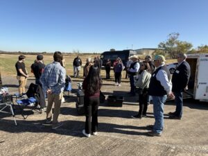
Space & Earth Osage LLC hosts tour on plans for UAV Skyway Range Published November 26, 2025 By Tracy Cozzens Osage LLC of Oklahoma welcomed members of the Osage Nation Congress for an in-depth tour and lunch briefing at Skyway Range, offering a first look at an ambitious vision to transform the area into a leading center for uncrewed aerial systems (UAS) innovation, testing and economic growth. The visit provided Osage leaders with a comprehensive […] Read more » Oklahoma Osage LLC Osage Nation Skyway Range UAS UAV
Defense GLONASS GLONASS receiver factory targeted by Ukraine Published November 26, 2025 By Tracy Cozzens The Ukrainian Unmanned Systems Forces on Nov. 26 struck a Russian factory that produces GLONASS navigation equipment for Shahed drones and Kalibr missiles, weapons used in a strike in Kyiv that killed seven people dthe day before, The factory is 1,000 km from the border between the countries. The report comes from Euromaidan, along with the […] Read more » GPS-guided missiles Russia Shahed UAVs Ukraine War
Complementary PNT Mapping Transportation UK Working Group discusses next steps to protect PNT Published November 25, 2025 By Tracy Cozzens The UK Hydrographic Office (UKHO) hosted the UK’s first cross-government geodesy, positioning, navigation and timing working group in October. Representatives from 19 government bodies shared insight on the risks, opportunities and interdependencies linked to PNT systems, including GNSS. On Nov. 19, the UK announced a £155M investment in PNT. The working group will continue to […] Read more » eLoran geodesy maritime navigation navigation PNT UKHO United Kingdom
Timing Siemens offers breakthrough time synchronization to fortify digital substations Published November 25, 2025 By Tracy Cozzens Siemens has unveiled its latest innovation for energy infrastructure: the Siprotec 5 Precision Time Protocol (PTP) Grandmaster Clocks (GMC). Built to secure the backbone of modern power grids, the GMC ensures resilient, fail-safe time synchronization for digital substations, safeguarding critical protection functions from disruption, shielding against external disturbances, and strengthening cybersecurity to boost overall grid […] Read more » grandmaster clock PTP Siemens Spirotec 5 substations utilities