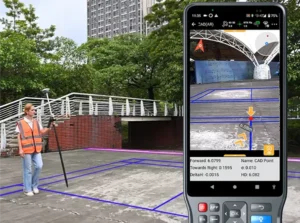
Receivers Survey SatLab launches SL8 laser RTK receiver Published December 11, 2025 By Tracy Cozzens Join the Discussion SatLab Geosolutions has launched a new GNSS receiver, the SL8. The SatLab SL8 Laser RTK combines dual cameras, GNSS, an inertial measurement unit (IMU) and visible laser technology to make surveying faster and easier. With non-contact measurement, image-assisted targeting, CAD live-view stakeout, and a built-in LoRa radio. It ensures smooth, reliable work even in complex […] Read more » GNSS receiver IMU laser measurement SatLab Geosolutions SatLab SL8 Laser RTK
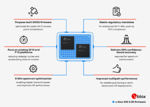
Mobile Receivers U-blox launches SIG 2.00 GNSS firmware Published December 11, 2025 By Tracy Cozzens Join the Discussion Dedicated firmware delivers AFC-compliant geolocation and adheres to 6 GHz spectrum rules, accelerating deployment of location-enabled Wi-Fi infrastructure. U-blox has released Standard Infrastructure GNSS (SIG) 2.00, a dedicated GNSS firmware solution for Wi-Fi 6E/7/8 access points operating in the 6 GHz band. Designed to meet Automated Frequency Coordination (AFC) requirements in the U.S. and Canada, […] Read more » GNSS firmware u-blox Wii-Fi infrastructure
Complementary PNT Defense Mobile NextNav to begin operating 5G-powered PNT network Published December 11, 2025 By Tracy Cozzens Join the Discussion The 5G PNT network in Santa Clara County will mark the first real-world demonstration of a 5G-powered backup to GPS NextNav Inc., a leader in next-generation terrestrial positioning, navigation, and timing (PNT) and 3D geolocation solutions, will commence operations of a 5G PNT network in Santa Clara County, California, as early as Dec. 11. Network […] Read more » 5G networks 5G PNT network NextNav PRS Santa Clara
Defense Autonomous AeroVironment expands Puma visual navigation system kit to Puma LE Published December 11, 2025 By Tracy Cozzens Join the Discussion AeroVironment has integrated its visual navigation system (VNS) kit with the Puma Long Endurance (LE) small unmanned aircraft system, delivering GNSS-denied navigation capability to ensure mission success. First introduced in 2022 for the Puma 2 AE and Puma 3 AE, the VNS kit uses advanced computer vision and onboard processing to deliver precise, GNSS-independent navigation. […] Read more » AeroVironment GNSS-denied Puma LE UAS visual navigation system
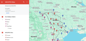
GNSS Galileo GLONASS GPS Moldova’s positioning system now uses Galileo Published December 10, 2025 By Tracy Cozzens Join the Discussion The MOLDPOS National Positioning System in Moldova has been integrated into the European Position Determination System (EUPOS), a pan-European GNSS augmentation service. The MOLDPOS navigational system uses both GPS and GLONASS, and now Galileo has been added, according to Anatol Ghilas, director of the Agency of Land Relations and Cadastre (ALRC) of Moldova. Ghilas said […] Read more » EUPOS Moldova MOLDPOS national positioning system
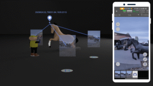
Survey Mobile Receivers Aurora Navigation introduces mobile visual RTK system Published December 10, 2025 By Tracy Cozzens Join the Discussion The small, light RTK receiver integrates the Anypos App and LoRa radio for high-precision surveying, photo surveys and 3D modeling. Aurora Navigation has launched the Astra1 Mobile Visual RTK, a professional-grade GNSS receiver engineered to redefine high-precision mobile data acquisition. The Astra1 is an ultra-compact (60g) solution designed to deliver reliable, centimeter-level positioning and advanced […] Read more » 3D modeling Astra1 Aurora Navigation RTK receiver visual RTK
Defense GNSS New GNSS interference report released Published December 10, 2025 By Tracy Cozzens Join the Discussion Shipborne Measurements Near the Kaliningrad Border A major new report by GPSPATRON gathered data between June 23 and Oct. 14, aboard a vessel routinely leaving the Port of Gdańsk and performing extended maneuvers in open water. The vessel conducted multiple offshore measurement campaigns, resulting in a shipborne dataset that provides a far more accurate representation […] Read more » Baltic Sea GNSS interference GPSPatron
Timing Hoptroff to deliver resilient precision timing to financial markets through LSEG’s platform Published December 10, 2025 By Tracy Cozzens Join the Discussion Hoptroff, a precision timing specialist, has partnered with the London Stock Exchange (LSEG) through its Hosting & Connectivity Partner Platform, which enables financial markets customers to access third-party applications and services via LSEG’s global connectivity services. The move reflects a fundamental shift in how financial services views timing infrastructure. No longer just a technical requirement, […] Read more » financial services Hoptroff London Stock Exchange LSEG precision timing timinng infrastructure
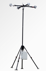
Defense Applications Autonomous MatrixSpace launches portable counter-drone radar Published December 10, 2025 By Tracy Cozzens Join the Discussion MatrixSpace has released the Portable 360 Radar, a rugged, easily transportable radar kit. The Portable 360 Radar delivers reliable close-airspace awareness with panoramic coverage for rapid-response counter-drone operations, from safe-guarding stadiums and large public gatherings, to border security and battlespaces. Traditional radar systems are cumbersome, slow to set up and limited in effectiveness for mobile C-UAS […] Read more » C-UAS counter-drone MatrixSpace MatrixSpace AiCloud Enterprise radar
Mapping Applications Mobile HERE and Precisely expand partnership to provide location data for businesses Published December 10, 2025 By Tracy Cozzens Join the Discussion HERE Technologies has expanded its partnership with Precisely, a data integrity company, to provide accurate and reliable location intelligence for business use cases across industry sectors. The partnership builds upon location intelligence capabilities within the Precisely Data Integrity Suite, giving companies deeper analysis, validation, and governance of their location data. Through the partnership, HERE and […] Read more » artificial intelligence data integrity HERE Technologies location accuracy machine learning Precisely