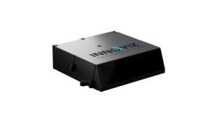
Transportation Autonomous Innoviz Technologies demos InnovizThree lidar at CES 2026 Published January 8, 2026 By Tracy Cozzens Join the Discussion Innoviz Technologies, a Tier-1 direct supplier of automotive-grade lidar sensor platforms and software stacks, is demonstrating its fully colored long-range lidar with camera at CES 2026 this week in Las Vegas. The InnovizThree creates a compact sensor-fusion module designed to significantly reduce OEM integration complexity. The solution combines lidar and RGB sensing in a single compact […] Read more » ADAS automotive camera CES 2026 Innoviz Technologies InnovizThree lidar OEM integration RGB
Mobile TDK launches STRIDE positioning software for wearables Published January 8, 2026 By Tracy Cozzens Join the Discussion TDK Corporation has announced Trusted Positioning STRIDE, an embedded pedestrian dead-reckoning (PDR) software solution engineered specifically for wearables — smart watches, head-mounted devices, glasses and compact sensors. STRIDE provides reliable positioning without the power and hardware demands traditionally required for GNSS-based tracking. STRIDE’s low-power, sensor-agnostic software engine fuses inertial data with GNSS and opportunistic wireless […] Read more » GNSS software GNSS tracking STRIDE TDK Trusted Positioning wearables
Space & Earth Galileo GNSS ESA celebrates 30 years of Galileo Published January 8, 2026 By Tracy Cozzens Join the Discussion To celebrate 30 years of the Galileo global navigation system, ESA created the following video. Read more » EGNOS ESA European Space Agency Galileo video
Survey Autonomous Wingcopter drones conduct aerial surveys in Japan Published January 7, 2026 By Tracy Cozzens Join the Discussion Wingcopter’s authorized partner in Japan, ITOCHU Corporation, has signed a Memorandum of Understanding (MOU) to collaborate on the practical use of Wingcopter’s long-range drones in aerial surveying together with PASCO Corporation and YellowScan Japan. The companies initially plan to use the Wingcopter 198 in disaster management where drone-based surveying is playing an increasingly important role, According […] Read more » aerial mapping drone survey hazards Japan land survey natural disasters UAV Wingcopter Wingcopter 198
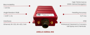
Defense Autonomous Anello launches Aerial INS at CES 2026 Published January 7, 2026 By Tracy Cozzens Join the Discussion Anello Photonics has launched the Anello Aerial inertial navigation system (INS), a compact, high-performance inertial navigation system built around the company’s Silicon Photonics Optical Gyroscope technology and integrated with multi-band GNSS receivers. Anello made the announcement at CES 2026, taking place this week in Las Vegas. The Anello Aerial INS is built for demanding aerial platforms […] Read more » ANELLO Photonics BVLOS CES 2026 inertial navigation system INS UAS
Chipsets Quectel issues cease and desist letters in response to ‘disinformation’ Published January 7, 2026 By Tracy Cozzens Join the Discussion Quectel Jan. 7 announced that it sent letters to Telit Cinterion, Thales Group, DBAY Advisors, Liberty Bell Project and Charles Parton demanding that they stop disseminating false and defamatory statements about Quectel regarding risks associated with its products’ security and the company’s purported connections to the Chinese government. The letters assert that Telit Cinterion, Thales […] Read more » Quectel
Survey Mapping Opinions A New Year’s resolution for National Spatial Reference System users Published January 7, 2026 By David B. Zilkoski Join the Discussion Happy New Year! I’ve always felt that a fresh calendar represents a world of new opportunities, and I wish you all a fantastic 2026. For many, this is a season for reflection and self-improvement, with goals typically centered on fitness, faith, personal growth or career milestones. As regular readers of this newsletter know, my primary […] Read more » modernized NSRS National Geodetic Survey NGS NSRS
Space & Earth Transportation Greece nano satellite MICE-1 supports maritime commuications Published January 6, 2026 By Tracy Cozzens Join the Discussion Greece now has its own internet of things (IoT) nano satellite in space, the MICE-1 (Maritime Identification and Communications systEm). MICE-1 was launched Nov. 28 aboard a Falcon 9 rocket from Vandenberg Space Force Base in California, as part of the Transporter-15 mission by SpaceX. MICE-1 is the first Greek nanosatellite specifically designed for maritime […] Read more » Greece maritime navigation MICE-1 nano satellite satellite launch
Autonomous Transportation Swift integrates high-integrity GNSS with Nvidia Drive AGX platform Published January 6, 2026 By Tracy Cozzens Join the Discussion Swift Navigation is collaborating with Nvidia to enable a more scalable, cost-effective approach to autonomous driving by integrating the Nvidia Drive AGX platform with Swift’s globally referenced, centimeter-accurate GNSS positioning. Swift Navigation offloads absolute localization to the GNSS sensor stack using its Swift Automotive Suite. The suite is a complete, modular software solution for safe, […] Read more » IMU sensor Nvidia Nvidia Drive AGX Nvidia DriveWorks Skylark corrections service Swift Nagivation
Space & Earth Complementary PNT GNSS Opinions Research & Development The rise of LEO PNT Published January 6, 2026 By Matteo Gala, Tyler Reid, Thyagaraja Marathe, Aurore Sibois, Srinivas Tantry, Kazuma Gunning, and Sunil Bisnath Join the Discussion Today’s commercial innovation requires infrastructure that moves at the same pace. Read more » commercial GPS Evolution Jammertest 2025 LEO constellation LEO PNT LEO satellitess low Earth orbit satellite medium Eartth orbit satellite Pulsar-0 Xona