Applications Mobile Rx Networks partners with Zephr.xyz to scale high-precision GNSS for Android devices Published January 6, 2026 By Tracy Cozzens Join the Discussion GNSS corrections company Rx Networks is collaborating with Zephr.xyz, whose software-based positioning SDK enables sub-meter accuracy on Android devices without requiring specialized hardware. Through this collaboration, Zephr.xyz has integrated Rx Networks’ TruePoint correction services, extending high-precision GNSS capability worldwide with the reliability, availability and continuity required for commercial-scale deployment. Operating on a global scale, Rx Networks is a […] Read more » Android GNSS corrections mobile devices Rx Networks TruePoint Zephr
Transportation Quectel releases 5G-advanced 3GPP R18 automotive-grade cellular module Published January 3, 2026 By Tracy Cozzens Join the Discussion Quectel Wireless Solutions has launched a 5G-advanced (5G-A) automotive-grade cellular module, the AR588MA. The module integrates dual-band GNSS supporting both L1 and L5 bands with up to 30 Hz output. Based on MediaTek’s latest-generation MT2739 platform, the AR588MA supports 5G-A communication technology and complies with the 3GPP R18 standard protocol. It features both NB-NTN and […] Read more » 5G-Advanced automotive cellular module MediaTek Quectel
Autonomous Defense MatrixSpace wins C-UAS Low-Cost Sensing Challenge Published December 30, 2025 By Tracy Cozzens Join the Discussion Winners of the U.S. defense Counter-small Unmanned Aircraft System (C-sUAS) Low-Cost Sensing (LCS) challenge have been announced. MatrixSpace Inc. was selected as the overall winner and will receive the top award of $500,000. Following the overall winner, the top three performers — Guardian RF, Hidden Level and Teledyne FLIR Defense — will each receive award […] Read more » counter-UAS LCS Challenge MatrixSpace UAS
Survey Machine Control / Agriculture Mapping Mobile Transportation Hexagon signs UN pledge to ensure robust PNT services Published December 29, 2025 By Tracy Cozzens Join the Discussion Hexagon has joined the Multilateral Memorandum of Understanding (MMoU) on Strengthening the Global Geodesy Supply Chain. The MMOU is a shared recognition by the United Nations Global Geodetic Centre of Excellence (UN-GGCE) — alongside member state government departments and agencies, private sector companies, organizations, associations, and academic institutions — that action is required to make […] Read more » geodesy Hexagon MOU United Nations
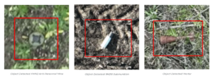
Defense Applications Autonomous Safe Pro unveils new algorithms for GPS-denied drone operations for U.S. Army Published December 23, 2025 By Tracy Cozzens Join the Discussion The latest generation of Safe Pro’s AI technology will be presented at U.S. Army exercise at Fort Hood, Texas Safe Pro Group, a developer of artificial intelligence (AI)-enabled defense and security solutions, has deployed upgraded AI algorithms to its patented Safe Pro Object Threat Detection (SPOTD) technology for drone operations in GPS-denied environments. The newly enhanced SPOTD […] Read more » army exercise artificial intelligence drone geospatial artificial intelligence geospatial data GPS-denied Safe Pro SPOTD U.S. Army Ukraine warfighter
Transportation Complementary PNT CPI TMD demonstrates quantum navigation at sea for UK Published December 18, 2025 By Tracy Cozzens Join the Discussion CPI Electron Device Business – TMD Technologies Division has successfully completed sea trials of its cquantum-hybrid inertial navigation system (INS) aboard the THV Galatea, operated by Trinity House, the General Lighthouse Authority for England, Wales, the Channel Islands and Gibraltar. This milestone shows that quantum-enabled sensing hardware can operate stably in maritime conditions, with the potential […] Read more » CPI TMD General Lighthouse Authorities Harlequin inertial navigation system INS quantum navigation sea trial THV Galatea University of Strathclyde
Mapping Autonomous Transportation Genesys launches high-definition ADAS maps for India Published December 18, 2025 By Tracy Cozzens Join the Discussion Genesys has developed India’s first large-scale high-definition maps engineered specifically for vehicles enabled with advanced driver assistance systems (ADAS). Covering more than 1 lakh km of India’s national highways, expressways and strategic corridors, this initiative marks one of India’s most ambitious road intelligence programs and establishes a new benchmark for automotive-grade precision. India’s highways account […] Read more » ADAS automotive CORS network Genesys high-definition maps highways India
Timing Applications Receivers Authentication added to GNSS timing receivers Published December 18, 2025 By Tracy Cozzens Join the Discussion Furuno will begin providing new firmware for its GNSS receivers for time synchronization, including models GT-100, GT-90 and GT-9001, which adds authentication features (OSNMA/QZNMA) and significantly strengthens anti-jamming and anti-spoofing measures. In fields that support critical infrastructure such as telecommunications, finance and power, GNSS vulnerabilities have become a major issue. The Furuno team participated in […] Read more » Furuno GNSS receivers Jammertest Jammertest 2025 timing receivers
SBAS GNSS Positioning Australia expands capabilities with Ginan V4 release Published December 17, 2025 By Tracy Cozzens Join the Discussion Geoscience Australia has released Ginan V4, the latest version of its home-grown, open-source toolkit for precise point positioning. Developed under the Positioning Australia program, Ginan V4 delivers world-class GNSS capabilities to innovators, researchers and industry professionals. Version 4 features a new intuitive graphical user interface (GUI) that makes data processing faster, easier and more accessible. […] Read more » Geosciences Australia Ginan precise point positioning SBAS
Complementary PNT BeiDou Galileo GNSS GPS Research & Development LEO satellites show promise in boosting navigation accuracy where GPS struggles Published December 17, 2025 By Tracy Cozzens Join the Discussion Low-Earth orbit (LEO) systems have emerged as a promising complement to GNSS, offering higher received power, better satellite geometry and broader spectrum options. Researchers aim to evaluate whether LEO-PNT can complement or enhance GNSS performance through large-scale simulations and design comparisons. Researchers from Tampere University and Universitat Autònoma de Barcelona published (DOI: 10.1186/s43020-025-00186-5) a comparative analysis in […] Read more » dilution of precision GNSS accuracy LEO constellation LEO-PNT Tampere University of Technology Universitat Autònoma de Barcelona