GNSS Applications Jammertest 2026 seeks applications for GNSS resilience demonstrations Published February 25, 2026 By Tracy Cozzens Join the Discussion Organizers of Jammertest, a large-scale trial of GNSS resilience technologies, is now open to applications. Jammertest 2026 will take place Sept. 14-18 in Norway. Application deadline is April 6. Jammertest is an annual event held at Andøya, recognized as the largest open PNT/GNSS resilience testing event in the world. The event provides a unique opportunity to test the […] Read more » GNSS resilience GNSS resiliency Jammertest 2026 Norway
Mapping CHC Navigation launches RS7 Handheld SLAM Scanner Published February 24, 2026 By Tracy Cozzens Join the Discussion Designed for BIM, indoor surveying and reality capture CHC Navigation announced the RS7, a new handheld SLAM (simultaneous localization and mapping) scanning solution, unveiled at the 2026 CHCNAV Connect Partner Conference. Built for BIM documentation, indoor surveying, renovation planning and complex spatial analysis, the CHCNAV RS7 is designed to help professionals capture high density 3D […] Read more » CHC Navigation CHCNAV handheld scanner RS7 SLAM
GPS NovAtel joins GPS Innovation Alliance Published February 24, 2026 By Jesse Khalil Join the Discussion NovAtel, part of Hexagon, has joined the GPS Innovation Alliance (GPSIA) as its newest member. Read more » GPS Innovation Alliance Hexagon | NovAtel
Survey Mapping SparkFun unveils quad-band GNSS rover with Galileo HAS support Published February 24, 2026 By Jesse Khalil Join the Discussion SparkFun Electronics has released the SparkPNT TX2, a quad-band GNSS rover that combines an IP67-rated aluminum enclosure with support for Galileo's High Accuracy Service (HAS) and standard RTK correction workflows. Read more »
Mapping GNSS Historical photos find their places Published February 23, 2026 By Tracy Cozzens Join the Discussion Michigan Technological University library and department of social sciences are examining 11,000 historical images of Michigan’s Upper Peninsula (Copper Country), to find precisely where a photographer stood to take the photo. The location will provide richer information about a place’s surroundings, especially in circumstances where structures or environmental landmarks are no longer present. The project also will […] Read more » GIS historical photos mapping Michigan Technological University
Survey Mapping Dubai Municipality joins International GNSS Services Published February 23, 2026 By Tracy Cozzens Join the Discussion First UAE government entity to join global geospatial organization Dubai Municipality has become the first government entity in the United Arab Emirates to join the International GNSS Services (IGS), a global organization specializing in satellite-based geospatial systems, precision surveying, and global reference frameworks. The IGS supports optimization of GNSS, plate tectonics monitoring, and the calculation […] Read more » Dubai Municipality GIS IGS International GNSS Services ITRF surveying UAE
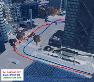
Autonomous Opinions Building GNSS you can trust: Lessons from testing in Germany and Japan Published February 23, 2026 By Jez Ellis-Gray Join the Discussion Urban environments present unique constraints that no laboratory or simulation can perfectly replicate. Read more » Focal Point Positioning Germany Japan STMicroelectonics urban environments
GNSS ESA to launch Celeste LEO-PNT on March 24 Published February 20, 2026 By Tracy Cozzens Join the Discussion News from the European Space Agency The European Space Agency (ESA) is preparing for the inaugural launch of the Celeste LEO-PNT in-orbit demonstration mission, with the first two satellites scheduled to lift off no earlier than March 24 aboard Rocket Lab’s Electron rocket from the company’s Māhia Launch Complex in New Zealand. Celeste will play a […] Read more »
Complementary PNT Autonomous GNSS Belgium company Agilica offers UWB-based local positioning for UAVs Published February 20, 2026 By Tracy Cozzens Join the Discussion Belgium company Agilica is offering a GNSS-independent onboard positioning system using ultra-wideband (UWB) technology. The system enables precise, autonomous drone navigation and landing, even in dynamic, GNSS-denied environments or on moving targets. The company says the system achieves centimeter accuracy in real time, enhancing safety and precision. It supports multiple drones and mobile assets in dynamic conditions. Developed in […] Read more » Agilica Belgium GNSS-denied UAV ultra-wideband UWB
GNSS Applications Finland seeks to criminalize unauthorized possession of GNSS jammers Published February 20, 2026 By Tracy Cozzens Join the Discussion On Feb. 19, the Finnish government submitted a legislative proposal to parliament to criminalize possession and import of radio-frequency jammers and spoofers, including those blocking GNSS signals According to Ministry of Transportation and Communications, the amendments would be made to the Act on Electronic Communications Services. The government proposes to amend the provisions on equipment […] Read more » confiscation Finland Finnish government jammers legislation NATO spoofers