Survey Mapping New Emesent GX1 is all-in-one SLAM lidar, RTK and 360° imagery scanner Published February 17, 2026 By Tracy Cozzens Join the Discussion Autonomous mapping company Emesent has launched the Emesent GX1, an integrated simultaneous localization and mapping (SLAM) and real-time kinematic (RTK) scanner. The company is exhibiting the GX1 at Geo Week 2026 (booth #911). The product achieves 5-10mm global accuracy to deliver high precision for topographic surveying and building and infrastructure construction. It can reduce the time required to survey a site by up to 95% with a single day of scanning replacing weeks of […] Read more » AEC BIM Emesent GX1 lidar mapping RTK SLAM surveying
Digital Edition Seen & Heard: Crust shifts, sinking plates and GNSS disruptions worldwide Published February 17, 2026 By Jesse Khalil Join the Discussion What on Earth is happening? Several interesting things, according to geologists who study data from the global network of geodetic-quality receivers. A team at the University of the Basque Country found the Iberian Peninsula rotating clockwise as Africa closes on Eurasia by 0.2 inches per year (5 mm), near Gibraltar and the Alboran region. Meanwhile, […] Read more » 0126 0226 GNSS GNSS jamming IATA mapping smartphone
Digital Edition GNSS Opinions Evolution: Machine learning for station specific Ionosphere prediction in GNSS positioning Published February 17, 2026 By Sunil Bisnath and Dr. Taiwo Osanyin Join the Discussion Ionospheric delay remains a significant error source in GNSS positioning, particularly for single-frequency users and during periods of enhanced space weather activity. Read more » 0126 0226 artificial intelligence GNSS ionosphere machine learning
Complementary PNT Space & Earth Topcon secures early access to Xona’s Pulsar satellite navigation service Published February 16, 2026 By Tracy Cozzens Join the Discussion Topcon Positioning Systems has signed a commercial agreement with Xona to secure early-adopter access to Pulsar, Xona’s low Earth orbit (LEO) satellite navigation constellation. This agreement positions Topcon among Xona’s first commercial customers preparing to integrate Pulsar into future high-precision positioning workflows. “The letter of agreement reinforces Topcon’s long-standing commitment to innovation and customer-driven technology leadership,” said Ron […] Read more » commercial agreement high-precision low Earth orbit satellite satellite navigation satellite navigation system Topcon Xona PULSAR Xona Space Systems
Receivers Simulators Safran acquires Syntony to strengthen position in resilient PNT market Published February 16, 2026 By Tracy Cozzens Join the Discussion Safran Electronics & Defense has acquired Syntony GNSS, a simulator and receiver company founded in 2015 in Toulouse, France. The acquisition is intended to strengthen Safron’s resilient PNT innovations. In 2023, Safran acquired Orolia, also for its GNSS and PNT expertise. Under the agreement, signed Feb. 13, Safran will take 100% of Syntony’s share capital, […] Read more » acquisition GNSS vulnerabilities mergers and acquisitions Orolia resilient PNT Safran Electronics & Defense Syntony
SBAS Survey Transportation Pakistan demonstrates advanced Pak-SBAS navigation system in desert rally Published February 16, 2026 By Tracy Cozzens Join the Discussion Pakistan’s national space agency SUPARCO (Space and Upper Atmosphere Research Commission) has achieved a major milestone in navigation technology with the successful launch of its Pak-SBAS satellite-based augmentation system (SBAS) device and service. The Pak-SBAS navigation service was rigorously tested in the extreme desert conditions of Cholistan during Cholistan Desert Rally 2026. The Cholistan desert […] Read more » Cholistan Desert Rally disaster response motorsport Pak-SBAS Pakistan precision navigation routing SUPARCO
Receivers Autonomous Defense Milanion products to feature NovAtel inside Published February 12, 2026 By Tracy Cozzens Join the Discussion At World Defense Show 2026 in Riyadh, Saudi Arabia, Milanion Group signed memorandum of understanding (MOU) with NovAtel to integrate assured positioning, navigation and timing into its unmanned land, maritime and air platforms, reports Global Defense News. A second MOU was signed with Elistair to introduce tethered unmanned aerial systems into Milanion’s ground and maritime […] Read more » assured PNT Elistair GNSS-denied ISR Milanion Group NovAtel World Defense Show
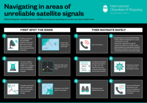
Transportation GNSS International shipping provided with tips on GNSS-denied navigation Published February 12, 2026 By Tracy Cozzens Join the Discussion The International Chamber of Shipping (ICS) and its members have produced an informational poster for ship crews that highlights strategies when GNSS signals are jammed or denied. The Navigating in Areas of Unreliable Satellite Signals poster is available for free on the ICS website. Crews are welcome to download and print it for display near the conning […] Read more » commercial shipping ICS poster ship navigation shipping
Galileo Timing Three ways R&D has shaped Galileo Second Generation Published February 10, 2026 By Tracy Cozzens Join the Discussion News from the European Space Agency Dedicated research and development, funded by European Union (EU) and European Space Agency (ESA) programs over the years, has played a key role in Galileo Second Generation. Among the innovations that will benefit the new satellites are the development of new atomic clocks, links that allow the satellites to “talk” to one another in orbit and a prototype ground station that can precisely pinpoint satellites in the sky. These advanced technologies will ensure Galileo continues to provide world‑class positioning, navigation and timing […] Read more » atomic clocks European Space Agency Galileo Second Generation R&D research and development timing
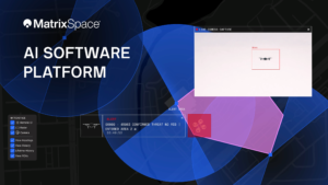
Defense Autonomous MatrixSpace updates platform to support multi-drone detection in real time for counter UAS Published February 10, 2026 By Tracy Cozzens Join the Discussion MatrixSpace has announced a major update to its edge-to-cloud MatrixSpace AI Software Platform. The platform now supports multi-sensor, multi-drone detection in real time for counter UAS applications. It delivers true threat assessment and early warning — detecting, tracking and identifying — to empower on-site and remote operators to make split-second decisions regarding airspace activity. The platform is […] Read more » counter-UAS drone countermeasures MatrxSpace software platform