Survey Mapping Divirod, OKI completes advanced GNSS-R terrain monitoring project in Fukuoka Prefecture Published February 10, 2026 By Tracy Cozzens Join the Discussion Divirod and Oki Electric Industry (OKI) have completed a project to monitor landslide risk and slope stability across vulnerable areas in the Fukuoka Prefecture of Japan. The project deployed Divirod’s next-generation ground deformation and anomaly-detection technology to provide continuous, high-resolution monitoring of mountainous terrain prone to extreme rainfall and seismic activity. The initiative supports Japan’s broader effort […] Read more » Divirod GNSS-R ground deformation Japan landslides OKI
Autonomous Defense Opinions UK’s Watchkeeper drone program nears the end: What went wrong and what’s to come Published February 10, 2026 By Tony Murfin Join the Discussion This month, news of the termination of a leading UAV program has sparked interest. Read more » Israel Ministry of Defense Ukraine United Kingdom
Mapping Wherobots, Felt partner to modernize geospatial data tools Published February 10, 2026 By Jesse Khalil 1 Comment on Wherobots, Felt partner to modernize geospatial data tools With this, both teams work to accelerate the end of siloed, legacy GIS giving way to a unified, cloud-native and AI enabled ecosystem Read more » GIS GIS software precision ag precision agriculture
Digital Edition GPS World EAB: The most promising approaches for limiting jamming in aviation Published February 10, 2026 By Jesse Khalil Join the Discussion In the Jan.-Feb. 2026 edition of GPS World magazine, we asked our experts, with the increase in reported GNSS jamming incidents affecting commercial aviation, what technical approaches show the most promise for ensuring reliable PNT? Read more » 0126 0226 aviation CRPA GNSS jammers
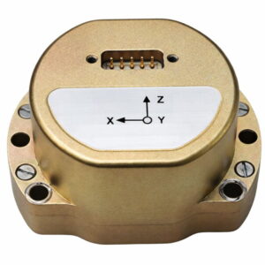
Transportation Mapping Survey Timing Micro-Magic offers high-precision MEMS IMU module Published February 9, 2026 By Tracy Cozzens Join the Discussion Micro-Magic has released the U4930 series, a reliable and cost-effective six-axis MEMS inertial measurement module that can be widely used in navigation, control and measurement fields for vehicles, ships and drones. Typical applications include vehicle/ship attitude measurement, UAV attitude reference and trajectory control, mobile mapping, track inspection, underwater high-precision navigation, and Satcom-on-the-Move. The U4930 series […] Read more » accelerometers autonomous vehicles gyroscopes MEMS inertial sensor Micro-Magic
Mobile BeiDou China rolls out BeiDou-based short messaging service for emergencies Published February 9, 2026 By Tracy Cozzens Join the Discussion China has launched a short messaging service leveraging BeiDou (BDS) to provide reliable communication during emergencies when ground-based mobile networks are unavailable, reports Xinhua. The service was introduced by China Space-Time Information Co. Ltd., the national operator of BeiDou services, in collaboration with major domestic telecom carriers. The service is be a supplement to terrestrial mobile networks, […] Read more » BeiDou China Space-Time Information Co. disaster relief emergencies emergency services short messaging services telecoms
Mapping Survey Aptella offers free RTK positioning for bushfire and flood recovery volunteers Published February 9, 2026 By Tracy Cozzens Join the Discussion Australia-based Aptella is offering free access to its AllDayRTK high-accuracy positioning service for volunteers and organizations involved in bushfire and flood recovery efforts. Reliable positioning aids in coordinating recovery operations, assessing damage and restoring essential infrastructure. However, extreme weather events often disrupt permanent GNSS base stations due to power outages and loss of internet connectivity. […] Read more » AllDayRTK Aptella Australia bushfire flood high-accuracy positioning positioning service RTK base stations RTK network
Defense Complementary PNT TrustPoint accelerates defense-grade, GPS-independent PNT with Phase II SBIR award Published February 6, 2026 By Tracy Cozzens Join the Discussion Contract strengthens the company’s growing portfolio of U.S. government-funded PNT initiatives TrustPoint has been awarded a $1.9 million Small Business Innovation Research (SBIR) Direct-to-Phase II contract focused on adapting and upgrading TrustPoint’s commercial C-band positioning navigation and timing (PNT) payload to integrate with U.S. Department of Defense (DoD) architectures and meet advanced government requirements. The Air […] Read more » Air Force Research Laboratory C-band PNT government contract Open Topic SBIR/STTR TrustPoint U.S. Air Force U.S. Department of Defense
Defense Mobile Timing Transportation Spirent partners with ESA to spearhead PNT resilience initiative for critical infrastructure Published February 6, 2026 By Tracy Cozzens Join the Discussion Project establishes innovative test framework to help UK operators, providers and suppliers adopt best practice and benchmark success Spirent Communications, now part of Keysight Technologies, has partnered with the European Space Agency (ESA) to lead an initiative aimed at increasing the resilience of positioning, navigation and timing (PNT) systems used in critical national infrastructure. Under […] Read more » critical infrastructure ESA NAVISP PNT resilience Royal Institute of Navigation Spirent Communications United Kingdom
Defense Complementary PNT Advanced Navigation’s inertial-centric intelligence succeeds in US Army’s contested environment Published February 4, 2026 By Tracy Cozzens Join the Discussion Successful deployment at APEX validates the technology as a crucial inertial-sensor stack for assured PNT on the modern battlefield. Advanced Navigation successfully demonstrated in April 2025 its inertial-centric intelligent navigation as part of the U.S. Army’s All-Domain Persistent Experiment (APEX), underscoring the ability to deliver reliable, high-accuracy navigation in GNSS-degraded and -denied conditions. Designed for […] Read more » Advanced Navigation APEX APNT Boreas D90 FOG INS laser velocity sensor U.S. Army U.S. Army APNT wheel-speed encoder